Brahmatal Trek Uttarakhand

Brahmatal Trek 2025

  • Region: Uttarakhand
  • Duration: 6 Days from Rishikesh/Haridwar/Dehradun
  • Grade: Easy to Moderate
  • Max Altitude: 12250 ft
  • Approx Trekking: 24Kms
  • Best Time: Winter

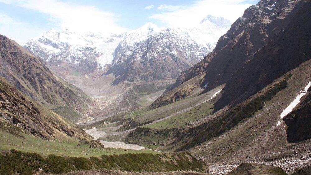
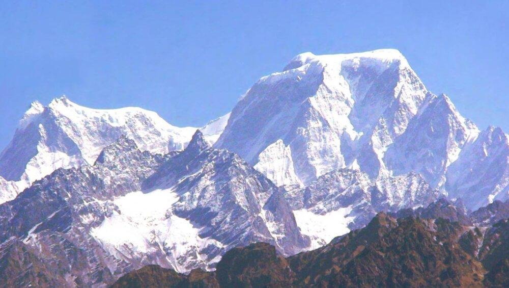
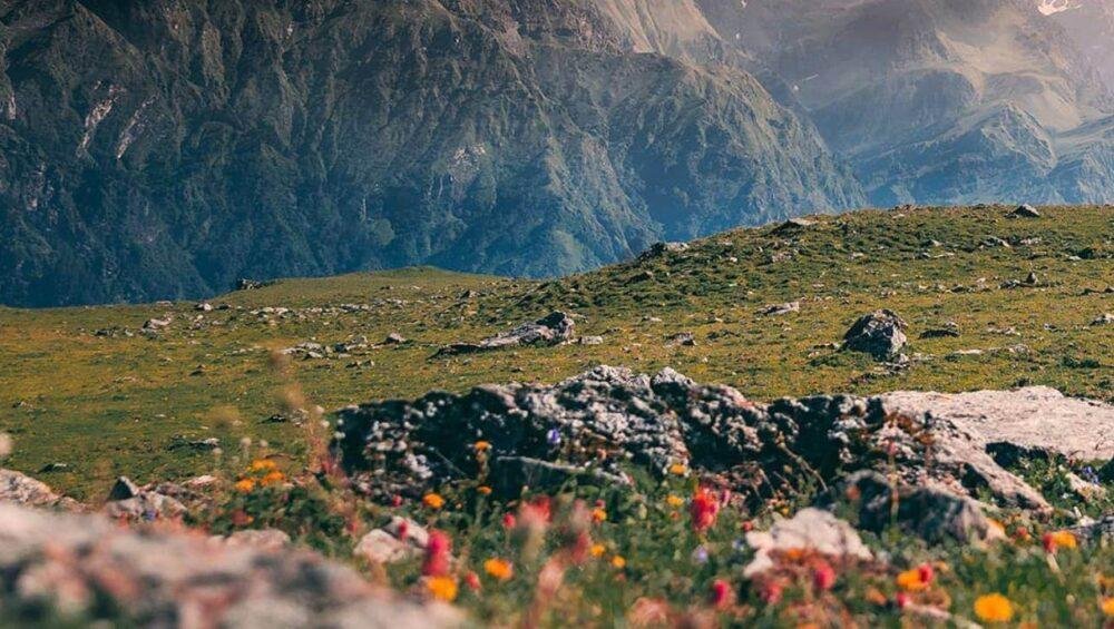
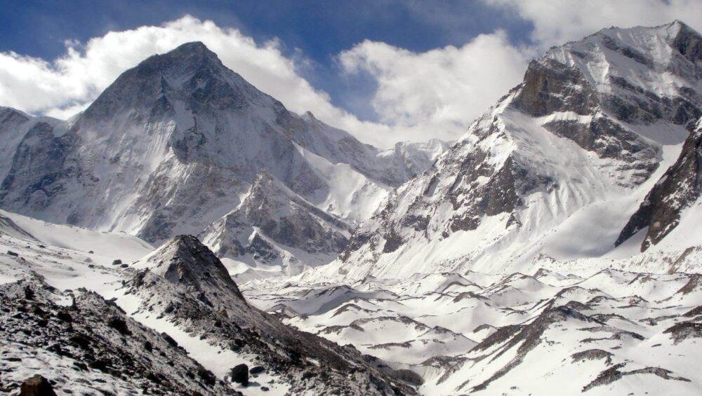
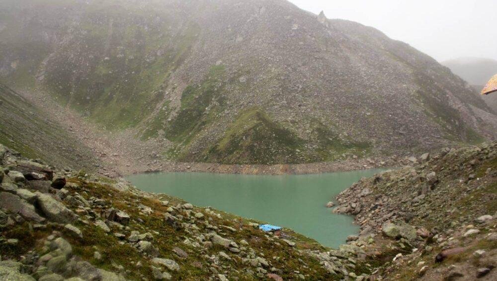
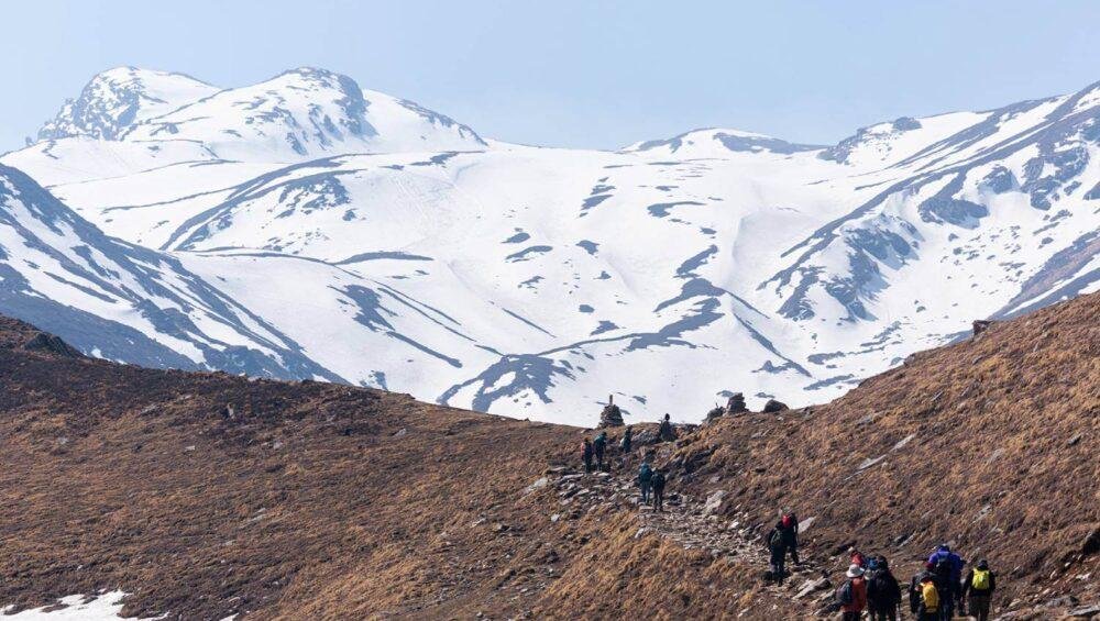
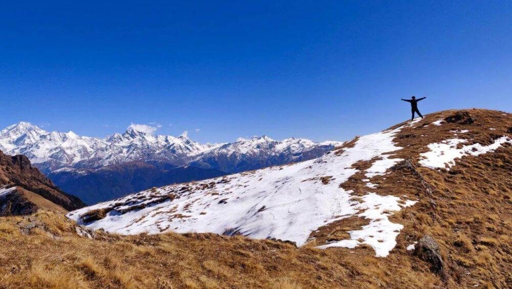
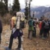
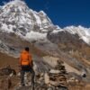
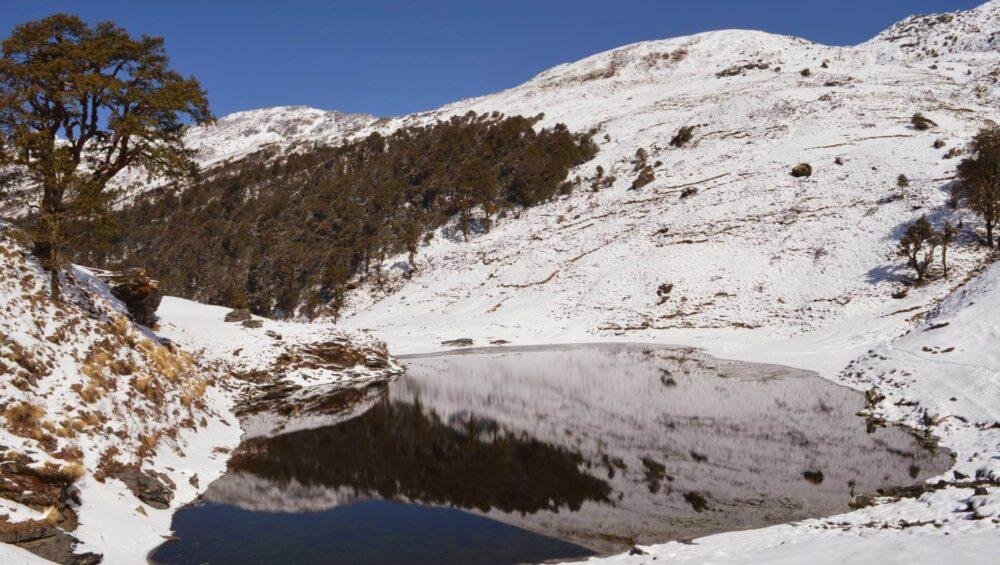
Popular as a snow winter trekking destination in Uttarakhand’s Garhwal Himalayas, 12,250 ft. Brahmatal Trek takes you to the high-altitude lake of Brahmatal. Surrounded by snow-capped mountains, the trek provides stunning views of the Himalayan Mountain ranges of Trishul, Chaukhamba, and Nanda Ghunti. The trek begins from the villages of Lohajung, located in the Chamoli district of Uttarakhand. A trek of moderate difficulty, the Brahmatal lake Trek can be undertaken by beginners and experienced trekkers, though trekking in the winter months adds a challenge, who should be prepared to face the cold and problems that come with a higher altitude. Covering a distance of 24 km in a span of 6 days, the trek leads through forests of oak and rhododendron, which await in full bloom during the flowering season in the months of March and April. The Brahmatal Lake, which is the highlight of the trek, has crystal waters which freeze completely during the colder winter months, making for a beautiful atmosphere, adding to the beauty of the nearby land which, too, gets a layer of snow.

Highlights of the Brahmatal Trek 2025

  • The trek takes you to the beautiful Brahmatal Lake, surrounded by snow-covered landscapes, whose crystal-clear waters reflect the landscape, and freeze over in winters.
  • The trek provides stunning views of the Himalayan Mountain ranges of Trishul, Chaukhamba, and Nanda Ghunti.
  • Brahmatal is known for being a winter trek with the trail being covered in snow, providing a unique and enchanting experience.
  • The trek leads through forests of oak and rhododendron, which await in full bloom during the flowering season in the months of March and April.

Best Time to Explore Brahmatal Trek

The best time to trek to the Brahmatal Lake is between the winter months of December to March, when the trail is covered in snow.

We can customize the Brahmatal Lake trek 2025 from the following locations:

  • Brahmatal Lake Trek from Haridwar
  • Brahmatal Lake Trek from Rishikesh
  • Brahmatal Lake Trek from Dehradun
  • Brahmatal Lake Trek from Delhi
  • Brahmatal Lake Trek from Mumbai
  • Brahmatal Lake Trek from Hyderabad
  • Brahmatal Lake Trek from Chennai
  • Brahmatal Lake Trek from Kolkata

Seeking a detailed itinerary for the Brahmatal Lake Trekking adventure in the Garhwal Himalayas? Fill out the enquiry form or call +91-9310109466.

Mayali Pass Trek Uttarakhand

Mayali Pass Trek 2025

  • Region: Uttarakhand
  • Duration: 11 Days from Rishikesh/Haridwar/Dehradun
  • Grade: Difficult
  • Max Altitude: 5300 m
  • Approx Trekking: 98Kms
  • Best Time: May to October

 At 17,338 ft., the Mayali Pass trek is one of the most beautiful trekking trails in Uttarakhand. It starts off from the village of Guttu and then moves to the village of Reeh, with surroundings covered by rhododendron and a dense forest of pine trees. Mayali Pass is a challenging adventure trail in nature to explore in the Himalayas. During the trek, one can see the mountain ranges of the Garhwal Himalayas, which include mountains like Thalay Sagar, Bhrigupanth, Kedarnath, and Kedar Dome, among many others. Covering a distance of more than 75 km, the Mayali Pass Trek can be covered in a span of 9 to 19 days. On the trek, one can view the Vasuki Tal, and the Mandani region, both, providing the most scenic of landscapes. The challenging Mayali Pass Trek is only suitable for trekkers with strong physical and mental endurance. It takes you through ascents and descents, rocky moraines, narrow routes, crevassed glaciers, and challenging environments. Climbing to the top of the trekking trail, one can view the gushing Mandakini River as well. At a distance of 7 km from Vasuki Tal, the trek then moves to Kedarnatha and onwards to Gaurikund before reaching the end.

Highlights of the Mayali Pass Trek 2025

  • The trekker gets to trek along the banks of the Bhilan Ganga river and its tributaries.
  • While trekking, the mountain ranges of the Garhwal Himalayas like the Thalay Sagar, Bhrigupanth, Kedarnath, and Kedar Dome can be viewed, from where one can view the setting sun.
  • On the trek, one can view the high-altitude lakes of Masartal, Pania Tal, and Vasuki Tal as well.
  • The trek, after reaching Mayali Pass, leads to Kedarnath at a distance of 7 km from the pass.
  • The trek provides mesmerizing views of glaciers like Chorabari, Companion, and Khatling.

Best Time to Explore Mayali Pass Trek

 The best time to trek to Mayali Pass is between the months of May to June and September to October.

We can customize the Mayali Pass trek 2025 from the following locations:

  • Mayali Pass Trek from Haridwar
  • Mayali Pass Trek from Rishikesh
  • Mayali Pass Trek from Dehradun
  • Mayali Pass Trek from Delhi
  • Mayali Pass Trek from Mumbai

Seeking a detailed itinerary for the Mayali Pass Trekking adventure in the Garhwal Himalayas? Fill out the enquiry form or call +91-9310109466.

Panwali Kantha Trek Uttarakhand

Chenap Valley Trek 2025

  • Region: Uttarakhand
  • Duration: 8 Days from Rishikesh/Haridwar/Dehradun
  • Grade: Easy to Moderate
  • Max Altitude: 15580 Feet
  • Approx Trekking: 60Kms
  • Best Time: July to August

Located in the Chamoli district of Uttarakhand, Chenap Valley is one of Uttarakhand’s hidden beauties that very few trekkers are aware of. At a height of approx 12000 to 15000 ft. The Chenap Valley offers amazing views of the Himalayan ranges of Nanda Devi, Nanda Kot, Nanda Ghunti, Trishul, Hathi, and Dronagiri. At the base of the Sona Shikhar peak, Chenap Valley is abundant with oak, deodar, and sal trees, along with a spread of rhododendron covering the vast meadow. The trek takes one through dense forests, streams, waterfalls, and a range of wildflowers, which are in full bloom during the months of May to October when they cover the whole valley. The trek begins from Vishnuprayag and then moves to the beautiful village of Thaing. Surrounded by lush green meadows, steep mountains and gushing streams, flower beds cover the entire valley in colors during the flowering season. Trekking to the Chenap Valley also involves crossing numerous rivers such as the Alakananda using a suspension bridge, a specialty of the region. A moderate trek with some challenging sections, the Chenap Valley trek covers a distance of 60 km in a span of 7-8 days.

Highlights of the Chenap Valley Trek 2025

  • The trek begins from Vishnuprayag, a confluence of the Alaknanda and Dhauliganga rivers.
  • The trekking trail involves crossing multiple rivers using suspension bridges making for an exciting adventure.
  • During the trek you will be surrounded by the Himalayan ranges of Nanda Devi, Nanda Kot, Nanda Ghunti, Trishul, Hathi, and Dronagiri.
  • Visit during the flowering season and witness the colorful carpeted meadows of the valley.

Best Time to Explore Chenap Valley Trek

Embark on the exclusive adventure of the Chanap Valley trek, a limited-time opportunity that unfolds its wonders for just a few months each year. The prime window to immerse yourself in this enchanting journey is from mid-July to late September, when the valley comes alive with a kaleidoscope of vibrant flowers and luxurious green landscapes. Ensure your expedition aligns with this ephemeral burst of nature’s beauty for an unparalleled and unforgettable experience in the heart of Chanap Valley. Don’t miss the chance to witness this seasonal spectacle – plan your trek during its fleeting embrace.

We can customize the Chenap Valley trek 2025 from the following locations:

  • Chenap Valley Trek from Haridwar
  • Chenap Valley Trek from Rishikesh
  • Chenap Valley Trek from Dehradun
  • Chenap Valley Trek from Delhi
  • Chenap Valley Trek from Mumbai

Seeking a detailed itinerary for the Chenap Valley Trekking adventure in the Garhwal Himalayas? Fill out the enquiry form or call +91-9310109466.

Panwali Kantha Trek Uttarakhand

Panwali Kantha Trek 2025

  • Region: Uttarakhand
  • Duration: 5 Days from Rishikesh
  • Grade: Moderate
  • Max Altitude: 10800ft
  • Approx Trekking: 40Kms
  • Best Time: May to June and September to November

Taking you through scenic lands of high-altitude meadows, and snow-capped mountain peaks, this less known trek in the Garhwal Himalayas of Uttarakhand makes for an interesting adventure in the hills. The Panwali Kantha Trek starts from the town of Ghuttu and passes through the high-altitude meadowed land of Panwali Kantha. A trek of moderate difficulty, the trek is suitable for those who have prior experience in trekking. At a height of 11,500 ft. the trek offers charming views of the mountain ranges of Yamunotri, Gangotri, Kedarnath, Badrinath,Thalay Sagar, Meru, Kirti Stambh, Chaukhambha, and Nilkanth, looking especially mesmerizing with the setting sun in the background. Located along the old pilgrimage route to Kedarnath, the Panwali Kantha Trek gets covered in crimson-colored rhododendrons during the months of April and May, lush green meadows after monsoon, and in a blanket of snow during winters, which also make for an interesting trek during the winters. Apart from the charming views of the Garhwal Himalayan mountains, the trek also takes one through lush and gorgeous forests and meadows of the region. The Panwali Kantha Trek spans approximately 40 km and typically takes 5 to 6 days to complete from Rishikesh/Haridwar/Dehradun.

Highlights of the Panwali Kantha Trek

  • The trek takes you to the beautiful Panwali Kantha meadow, a high-altitude meadow, surrounded by the snow-capped peaks of the Himalayas.
  • During the months of April and May, the trail is decked with red and pink rhododendrons.
  • The trekking trail passes through the remote villages of the region and provides an opportunity to witness the local culture and lifestyle of the people.
  • While trekking, the landscape offers some amazing views of the Himalayan mountains of Yamunotri, Gangotri, Kedarnath, Badrinath,Thalay Sagar, Meru, Kirti Stambh, Chaukhambha, and Nilkanth.

Best Time to Explore Panwali Kantha Trek

The best time to trek to Panwali Kantha is between the months of May to June and September to October.

We can customize the Panwali Kantha trek 2024 from the following locations:

  • Panwali Kantha Trek from Haridwar
  • Panwali Kantha Trek from Rishikesh
  • Panwali Kantha Trek from Dehradun
  • Panwali Kantha Trek from Delhi
  • Panwali Kantha Trek from Mumbai

Seeking a detailed itinerary for the Panwali Khal Trekking adventure in the Garhwal Himalayas? Fill out the enquiry form or call +91-9310109466.

Kanari Khal Trek Uttarakhand

Kanari Khal Trek 2025

Situated at a distance of 11 km from the Bagini Glacier, the Kanari Khal Trek takes one through the beautiful regions of the Garhwal Himalayas. With a height of 14,812 ft. the trail to Kanari Khal is covered with rivers, waterfalls, meadows, forests, villages, and grounds carpeted with wildflowers. The trek is of an easy pace and has scenery that keeps changing every few kilometers. Providing a beautiful landscape of Uttarakhand, Kanari Khal Trek begins from the village of Jumma, which is an hour ride away from Joshimath. Close to the border of Tibet, Jumma’s weather involves strong and cold winds. The trek then moves to the village of Ruing after crossing the Dhauliganga over a steel suspension bridge. Meandering through forests and steep trails, Ruing is just one of the more fascinating stops on the trek. Even though hiking afterwards can be slightly challenging, the view from the top compensates for everything, looking something out of a painting. Providing a view of the mountain ranges of Hathi, and Ghori, the trails are surrounded by the mighty Himalayas at all times. Covering a span of 5 to 8 days, the trek covers a total distance of 35 km.

Highlights of the Kanari Khal Trek

  • Kanari Khal Trek, on reaching the top, provides for a beautiful blanket of alpine flowers spread across the region.
  • Visiting in summer, Kanari Khal is filled with flowers in full bloom, making for a pretty sight.
  • During the trek you can view the mountain ranges of Hathi, and Ghori as well as other snow-capped mountain peaks in the surrounding area.
  • En route to the Kanari Khal, the trek will lead you to the gushing Bagini River.

Best Time to Explore Kanari Khal Trek

 The best time to trek to Kanari Khal is between the months of May to June and September to October.

Seeking a detailed itinerary for the Kanari Khal Trekking adventure in the Garhwal Himalayas? Fill out the enquiry form or call +91-9310109466.

Gulabi Kantha Trek

Gulabi Kantha Trek 2025

  • Region- Uttarakhand
  • Duration – 5 Days from Rishikesh/Haridwar/Dehradun
  • Base Camp – Hanumanchatti
  • Altitude– 3789 Meters
  • Best Time – Throughout the year
  • Trek Grade – Moderate
  • Total Trekking– 28 Km

A lesser-known trek in the Garhwal Himalayas, the Gulabi Kantha Trek leads to the vast and lush meadow of Gulabi Kanth, located in the Uttarkashi district of Uttarakhand.

At a height of more than 12,000 ft. the trek passes through trails covered in wildflowers, green meadows, dense forests of oak trees and deodar trees, and an abundance of flora and fauna of the region. Lying on the way to the freshwater lakes of Dodital, the trek to Gulabi Kantha provides a complete view of the peaks of some of the most stunning Himalayan Mountain ranges such as Bandarpoonch, Kalindi sirkala, Shivalik, and Chaukhamba. Located close to the pilgrimage site of Yamunotri, the Gulabi Kantha trek begins from Hanuman Chatti, the base camp for the trek also known for the confluence of the rivers of Yamuna and Hanuman Ganga. Covering a distance of 25 to 28 km, the Gulabi Kantha Trek can be completed in a span of 5 days.

Highlights of the Gulabi Kantha Trek

  • The base camp of the Gulabi Kantha trek is Hanuman Chatti, which is located at the confluence of Hanuman Ganga and Yamuna River.
  • The trek provides amazing views of the mountain ranges of Bandarpoonch, Kalindi sirkala, Shivalik, and Chaukhamba.
  • The trek passes through the freshwater, high-altitude lake of Dodital.
  • The wide and lush meadow after completing the trek and reaching Gulabi Kantha during the flowering season provides a visual treat.

Best Time to Explore Gulabi Kantha Trek

The best time to trek to Gulabi Kantha is between the months of April to June and September to October.

Seeking a detailed itinerary for the Gulabi Kantha Trekking adventure in the Garhwal Himalayas? Fill out the enquiry form or call +91-9310109466.

Bagini Glacier Trek Uttarakhand

Bagini Glacier Trek 2025

  • Region – Uttarakhand
  • Duration: 9 Days from Rishikesh/Haridwar/Dehradun
  • Trek Grade: Moderate
  • Max Altitude: 14800 Ft.
  • Approx Trekking- 43 to 45Kms
  • Best Time to Visit- Summer & Autumn Season

Covering a distance of more than 45 km in a span of around 9 days, the Bagini Glacier Trek is one of the more mesmerizing treks that you can undertake in the Garhwal Himalayan region of Uttarakhand. At a height of 14,816 ft. Bagini Glacier trek passes through picturesque landscapes, remote villages, and offers breathtaking views of several majestic peaks. Beginning from the town of Joshimath, near Badrinath, the trekking trail passes through numerous villages such as Jumma, Ruing, and Dronagiri before reaching Bagini Base Camp onwards to the Bagini Glacier. Offering stunning views of the mountain ranges of Changabang, Kalanka, and Dunagiri, trekking to the glacier is simply awe-inspiring. Considered to be a trek of moderate difficulty, this trek is not for beginners who are strongly advised against this expedition. For those with prior trekking experience, a visit to the Bagini Glacier can turn out to be so much fun. Located within the perimeter of the Nanda Devi National Park, the Bagini Glacier Trek proves to be a real challenge with its slippery and steep terrain that make it hard for the unskilled and hence requires some amount of technical skills to cover this expedition.

Highlights of the Bagini Glacier Trek

  • The trek takes you to the gorgeous Bagini Glacier and provides mesmerizing views of the surrounding Himalayan peaks.
  • The trail passes through the base camp of Changabang, a stunning peak in the Garhwal Himalayas which further offer charming views of various mountain ranges such as Hathi, Ghori,Satminal, Dunagiri,Garur peak, Trishuli, Rishi, and Kalanka.
  • The trek also passes through the base camp of Kalanka, another prominent mountain in the region.
  • On the trek, trekkers visit the Dronagiri village and get a taste of the culture and lifestyle of the villages living in this region of the Garhwal Himalayas.

Best Time to Explore Bagini Glacier Trek

The best time to trek to Bagini Glacier is between the months of May to June and September to October.

Seeking a detailed itinerary for the Bagini Glacier Trekking adventure in the Garhwal Himalayas? Fill out the enquiry form or call +91-9310109466.

Satopanth Lake Trek Uttarakhand

Satopanth Lake Trek 2025

The Satopanth Lake Trek follows the trail to the Satopanth Tal, one of the high-altitude lakes located in Uttarakhand at a height of 15,100 ft. A challenging trek that takes you through mesmerizing landscapes, elevated meadows, and crystal-clear lakes, the Satopanth Lake Trek covers a distance of around 50 km in a span of 5 to days. Shaped in the form of a triangle, the three corners of this glacial lake is where the Hindu gods, Brahma, Vishnu, and Mahesh are said to have meditated, making the lake an extremely pious one for Hindus, and is also visited by pilgrims alike during their pilgrimage. A beautiful lake hidden among the Garhwal Himalayas, it shows itself after a challenging trek and is to be undertaken only by experienced trekkers. Beginning from the popular pilgrimage site of Badrinath, the Satopanth Lake Trek gives trekkers a hard time owing to the high altitude, harsh weather, and rough terrains, but is nonetheless one that is enjoyed by trekking enthusiasts.

Satpant Lake is one of the best trekking places in Uttarakhand for those who are keen on experiencing spirituality, adventure, nature, meadows, and snow-capped Himalayan peaks in one trip in the Himalayas.

Highlights of the Satopanth Trek

  • The trek leads you to the mesmerizing glacial lake of Satopanth Tal.
  • The trek offers stunning views of the Swargarohini peaks, considered sacred for the followers of Hinduism.
  • The trek moves through beautiful meadows like the Chakratirtha, which offers panoramic views of the surrounding mountain ranges.
  • During the trek you come across the village of Mana, which falls on the Indo-China border and is therefore called India’s first village.
  • The Satopanth Lake provides beautiful views of the surrounding mountain ranges of Chaukhamba, Neelkantha, Swargarohini and Balakun.
  • During the trek, you will also come across the beautiful Vasundhara Waterfall and Sahastradhara- the thousand-fold spring.

Best Time to Do Trek

 The best time to trek to Satopanth Lake is between the months of May to June and September to October.

Seeking a detailed itinerary for the Satopanth Trekking adventure in the Garhwal Himalayas? Fill out the enquiry form or call +91-9310109466.


Pangarchulla Peak Trek Uttarakhand

Pangarchulla Peak Trek 2025

Pangarchulla Peak Trek, a hidden gem in the Garhwal Himalayas and one of the best moderate to challenging trekking trails to explore in Uttarakhand. Located among the beautiful ranges of the Garhwal Himalayas, the Pangarchulla Peak Trek is a trek that promises an exciting time. Situated within the Nanda Devi National Park, the Pangarchulla Peak Trek is completed at an altitude of 15,069 ft. With the summit point at such an elevation, the trek takes over 5 days and covers a distance of around 44 km. A trek of moderate difficulty, the Pangarchulla Trek begins from the Joshimath village of Uttarakhand. Taking one through green meadows, cliffside villages, and mountain farms, the trek offers some of the most scenic landscapes of the state. During the trek, the mountain ranges of Nanda Devi and Chaukhamba can also be seen. Standing mightily and covered in snow, the view of the Himalayan ranges from the Pangarchulla Peak is simply breathtaking. Though the climb to the summit can be challenging due to the terrain and weather, it eventually leads to the sweet reward of overlooking the beautiful region of the Garhwal Himalayas.

Highlights of Pangarchulla Peak Trek

  • The trek offers breathtaking views of the snow-capped ranges of the Himalayas such as the Nanda Devi, Trishul, Dronagiri, Hathi Ghoda, Chowkhamba, Mana, Neelkanth.
  • Visiting during the months of March and April can lead you to view the fully bloomed Rhododendrons who carpet the forests and provide colors to the dense oak and pine forests.
  • The trek will lead you through vast meadows, dense forests, and streams of the region.
  • Passing through the villages of Kharchi, Lower Tugashi and Upper Tugashi, the trek offers a chance to understand the lifestyle of those living in the mountains.

Best Time to Do Pangarchulla Peak Trek

The best time to trek to Pangarchulla Peak is between the months of April to June and September to November.

Seeking a detailed itinerary for the Pangarchulla Peak Trekking adventure in the Garhwal Himalayas? Fill out the enquiry form or call +91-9310109466.

Mukta Top Trek Uttarakhand

Mukta Top Trek 2025

Mukta Top Trek is an offbeat winter trek that is taken up by trekkers who wish to explore a more isolated and secluded setting. Located in the region of the Garhwal Himalayas, in the Uttarkashi district of Uttarakhand, Mukta Top, at a height of 11,837 ft. is one of the most beautiful places to trek in the state. Starting at Kuflon, on the trek you are greeted with dense forests of bamboo, the most you can see on a trek in the state. With a rise in elevation, dense forests of maple, oak, rhododendron, and pine trees are what cover the surroundings. On reaching the summit, Mukta Top provides mesmerizing views of the nearby mountain ranges of Gangotri, Bandarpunch, Kala Nag, Jaonli, Draupadi, and Danda. The trek leads through some beautiful covers of forests and rewards you with the snowy mountains on reaching the top. A popular winter trek, the Mukta Top Trek is interesting due to the fresh snow that covers the summit. With a difficulty level of easy to moderate, the Mukta Top Trek is something that can be achieved by beginners and can be a magical experience for those who wish to start trekking. Covering a distance of 29 km, the Mukta Top Trek can be done in 6 days.

Highlights of the Mukta Top Trek

  • For most of the trek you will find yourself surrounded by dense forests of Uttarakhand providing an exhilarating experience.
  • With such a great forest cover, there is also an abundance of birds which is amazing for birdwatching.
  • From the summit, you can get enthralling views of mountain ranges like Gangotri, Bandarpunch, and Draupadi among others.
  • Being a winter trek, you get to witness snowfall and a chance to view fresh layers of white snow.
  • A trek that is lesser known, it is secluded and offers a peaceful atmosphere.

Best Time to Do Trek

The best time to trek to Mukta Top would be between the months of October to June.

Seeking a detailed itinerary for the Mukta Top Trekking adventure in the Garhwal Himalayas? Fill out the enquiry form or call +91-9310109466.